


I. A Mongol Ghost in a Soviet Machine
To map the Mongolian People's Republic in the interwar years is to capture a nation in a state of profound, suspended animation — and, if one is honest about the period, one of intermittent terror.
This hand-painted work focuses on the decades following the revolutionary proclamation of 1924 but preceding the 1941 adoption of the Cyrillic alphabet. It is a portrait of a republic that was modern in its political structure but still anchored to a civilizational past by the vertical elegance of its script. What I have tried to capture is a contradiction: a state simultaneously sovereign and dependent, culturally continuous and violently transformed.
By retaining the traditional vertical Mongolian script within modern territorial boundaries, I am arguing that this period represents a coherent — if deeply troubled — phase of statehood. It is a glimpse of Mongolia after the consolidation of the revolutionary state, but before the linguistic reforms that would reorient its written soul toward the Soviet sphere. The map preserves what Soviet policy was already preparing to destroy.

Mongol Propaganda Poster from WW2 Era
II. Framing the Interwar World: Borders and Geopolitical Context
The borders correspond to the internationally recognized territory of interwar Mongolia, but the surrounding political environment is what fixes the work firmly within its historical moment.
To the north lies the Soviet Union — not merely a neighbor but an ideological patron, military guarantor, and eventual arbiter of Mongolian political life. To the south, the Republic of China, whose capital during most of this period was Nanjing rather than Beijing, and whose nominal claim over Mongolian territory made the republic's sovereignty perpetually contingent. These placements prevent the retrospective projection of Cold War cartography onto an earlier and more ambiguous geopolitical reality.
I have omitted Tannu Tuva, and I want to be direct about why. The region's gradual absorption into the Soviet sphere between the 1910s and 1944 is one of the more instructive case studies in the geopolitics of the era — a small steppe territory maneuvered out of Chinese suzerainty, declared a Soviet protectorate, and eventually incorporated as an autonomous oblast. It is a story that illuminates precisely the asymmetrical pressures Mongolia itself navigated, and I debated its inclusion. In the end, I chose omission rather than oversimplification: to show Tuva would require addressing its status in 1924 versus 1940 in ways that exceed this map's frame.
Mongolia appears here neither as the center of a steppe empire nor as a Soviet appendage — though it was, in important ways, both. It is shown instead as a strategically situated republic maintaining the outward forms of sovereignty under conditions that severely constrained it.

A Soviet Satellite State
III. Script and Sovereignty: The Politics of Orthography
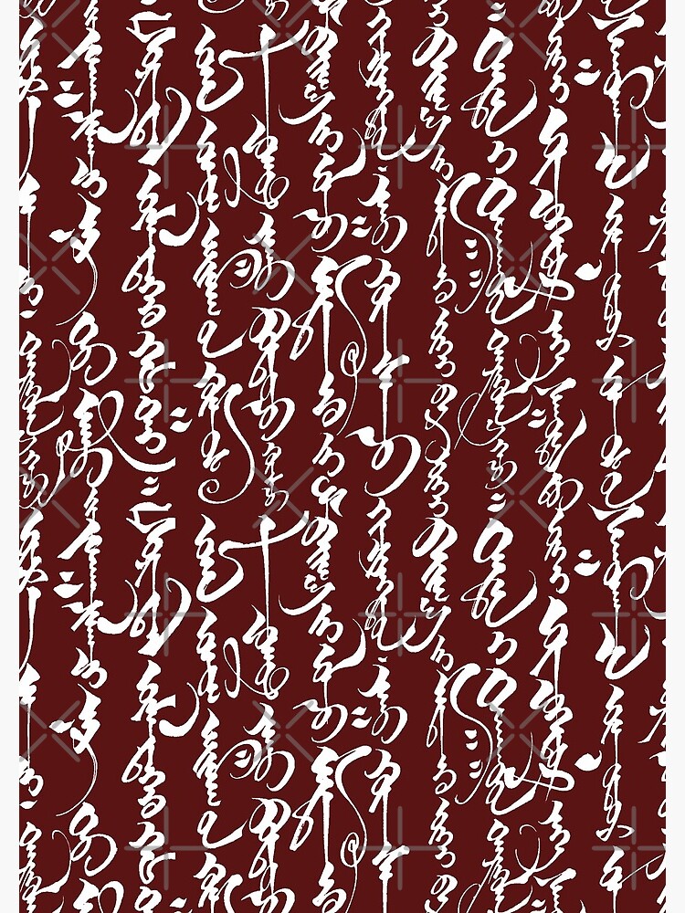
The most striking feature of this map is its use of traditional vertical Mongolian script, and that choice is not decorative. It is an argument.
At the center of the composition appears:
ᠮᠣᠩᠭᠣᠯ ᠤᠯᠤᠰ Mongol Uls — "Mongol State."
Written vertically and read left to right, following classical convention. Major geographic identifiers follow the same hand:
ᠤᠯᠠᠭᠠᠨᠪᠠᠭᠠᠲᠤᠷ — Ulaanbaatar
ᠬᠣᠪᠳᠤ — Khovd
ᠪᠠᠶᠠᠨ-ᠥᠯᠭᠡᠢ — Bayan-Ölgii
ᠥᠮᠦᠨᠡᠭᠣᠪᠢ — Ömnögovi
ᠳᠣᠷᠨᠣᠳ — Dornod
Rendering this script by hand was the most demanding element of the work, and I want to explain what that process required. Unlike alphabetic systems written left-to-right, classical Mongolian is written in vertical columns, with letterforms that change shape depending on their position within a word — initial, medial, or final. Many characters differ only by subtle variations in stroke curvature or length. Vowel harmony affects orthographic structure in ways that are not intuitive to non-native learners, and the ligature patterns compound the difficulty considerably.
My practice relied on the digital manuscript and cartographic materials available through the Tokyo University of Foreign Studies land map archive and the Library of Congress Mongolian collections, which provided both lexical confirmation and visual precedent for spacing, proportionality, and historical form. The UNESCO documentation on Mongolian traditional calligraphy was especially useful for clarifying stroke order and stylistic conventions. Individual place names were drafted many times over before reaching a form I felt was internally consistent. Maintaining vertical alignment across the page while preserving legibility at cartographic scale introduced further complications: what reads clearly in manuscript form can collapse visually when reduced.
I do not claim calligraphic mastery. The result is interpretive rather than archival — a modern hand attempting to approximate a pre-reform administrative script. But structural correctness mattered to me, and I rendered Ulaanbaatar in its full traditional form rather than phonetic shorthand, adhering to classical literary standards throughout.
Mongolian calligraphy
The historical stakes of this choice are worth dwelling on. In 1941, the Mongolian state adopted Cyrillic orthography under Soviet guidance. That reform — the second script change in fifteen years, following an abortive Latin transition in the 1930s — was not simply a technical adjustment. It was a symbolic rupture: a reorientation of literacy, education, and cultural alignment toward the Soviet sphere, and a severing of the written connection to the broader Mongol world, including Inner Mongolia, Buryatia, and the vast pre-modern archive of Buddhist and administrative texts. By retaining the classical script while depicting the interwar republic, this map captures Mongolia before that rupture — preserving the visual continuity of a written tradition already under ideological threat.
The result is intentionally hybrid: a twentieth-century socialist state written in a premodern hand.

Contemporary production of Mongolian calligraphy
IV. The Terror Behind the Map
I would be dishonest if I framed the interwar period as merely "transitional" without confronting what that transition actually meant in human terms.
The 1930s in Mongolia were a decade of Stalinist purges on a devastating scale. Under the direction of Soviet advisors and the Mongolian People's Revolutionary Party leadership — most infamously Khorloogiin Choibalsan, who modeled himself closely on Stalin — somewhere between 25,000 and 35,000 people were executed between 1937 and 1939 alone. The primary targets were the Buddhist clergy. Mongolia had been one of the most densely monasticized societies in the world: by some estimates, a third of the male population had been monks before the revolution. By 1940, nearly all of the country's approximately 700 monasteries had been destroyed, and roughly 17,000 monks had been killed. The rest were laicized, imprisoned, or driven into secular life.
This is not incidental context. It is the context. The traditional Mongolian script I have rendered on this map was inseparable from Buddhist literary culture — from the sutras, the chronicles, the administrative records produced in monastery scriptoria across the steppe. The visual culture of the script survived into the late 1930s in part because the Soviet-backed state had not yet found a mechanism to replace it. The Cyrillic reform of 1941 completed what the purges of the monasteries had begun: the dismantling of the institutional infrastructure through which the classical written tradition had been transmitted.
When I chose to represent this period through the script rather than through the political structure, I was making a claim about what was being lost — and what was still, just barely, present. The map is also, in this sense, an elegy.
V. Interior Order: Provinces, Space, and Scale
The internal structure of the map emphasizes aimags — provinces — rather than urban density. This reflects a genuine historical reality: Mongolia was, and in most respects remains, a country defined by its vast pastoral geography rather than its cities. Provincial names are distributed vertically across expansive territory, reinforcing both spatial scale and the calligraphic rhythm of the script.
The Gobi region in the south is treated as tonal field rather than empty margin. The western provinces — Khovd, Bayan-Ölgii — anchor the Altai corridor and gesture toward the ethnically Kazakh populations that have always complicated any simple narrative of Mongolian cultural unity. Dornod defines the eastern steppe, where the proximity to Manchuria and the memory of the Khalkhin Gol conflict of 1939 still haunt the landscape. Ulaanbaatar — still sometimes called Urga in Russian-language sources of the period, or Niislel Khüree in Mongolian — appears as a single node within vast territorial continuity.
The compositional restraint I have tried to maintain resists the cartographic impulse to overfill space. Mongolia's scale is part of its meaning, and I wanted the map to honor that.

A Mongol Poster from 1931: "Do you know how to write?"
VI. The Hybrid Problem: Modern Borders, Older Civilization
There is a tension at the heart of this map. When traditional Mongolian script functioned as the primary administrative medium, the "Mongol world" extended well beyond the boundaries of any modern state. Inner Mongolia, Buryatia, the Kalmyk steppe, the Hazara populations of Afghanistan — all formed part of a wider cultural-linguistic sphere, one defined by the script, by Tibetan Buddhist practice, and by the memory of the Chinggisid empire. For those interested in the deeper roots of that civilization, I invite you to explore my research paper on the topic.
The map produces a deliberate anachronism: the territorial lines are twentieth-century; the script predates them by centuries. This tension foregrounds the distinction between civilizational continuity and political contraction — between what the Mongolian script means as a cultural object and what the borders of the MPR represent as a political fact. The interwar republic inherited an expansive historical identity while governing a circumscribed, satellite territory. I find that contradiction more interesting than any attempt to resolve it.
It is a tension, moreover, that Mongolia itself has never fully resolved. The contemporary debate over script revival in Mongolia — where the traditional script is taught in schools but Cyrillic remains dominant — re-enacts, in milder form, exactly the dilemmas this map tries to visualize. The question of which alphabet a people writes in is never merely technical.
VII. Calligraphy and Historical Atmosphere
The brushwork adopts a manuscript aesthetic rather than typographic regularity. Strokes are elongated and occasionally irregular, evoking eighteenth- and nineteenth-century map hands without claiming direct reproduction of any specific archival model.
As in my Ottoman and Tibetan work, I have prioritized structural correctness over antiquarian perfection. I am not a native reader of Mongolian, and I will not pretend otherwise. What I have tried to produce is historically plausible and internally consistent — a modern interpretive hand, working from archival precedent, attempting to render a past that resists domestication.
The 1931 Mongolian propaganda poster I have included — "Do you know how to write?" — captures something essential about the period's ambivalence. The revolutionary state promoted literacy, but in which script? In what language? Toward what cultural ends? Those questions were never fully answered before they were made irrelevant by the Cyrillic reform. The poster's exhortation hangs in the air above a decade of institutional destruction.
VIII. A State Not Yet Fully Rewritten
The interwar Mongolian People's Republic was, in the end, a place of profound paradox: ideologically revolutionary and culturally continuous, formally sovereign and structurally dependent, increasingly literate and catastrophically bereaved of its learned class. The terror of the late 1930s makes any purely aesthetic account of this period incomplete.
But I am also a cartographer and, in some sense, an apologist for the map as a form of historical argument. What a map can do, what I have tried to do here, is hold contradictions in suspension rather than resolve them. The traditional script persisting within Soviet-aligned borders is not a mistake. It is the point. It says: this is what Mongolia looked like in the brief interval between revolution and reform, between independence and absorption, between the old written world and the new one being prepared to replace it.
It is a portrait of Mongolia not as empire, not as satellite, and not as contemporary democracy — but as a republic that was still, in 1935, writing itself in a hand its own government was already planning to abolish.
Bibliography (Selected)
Atwood, Christopher P. Encyclopedia of Mongolia and the Mongol Empire. New York: Facts on File, 2004.
Bawden, C. R. The Modern History of Mongolia. London: Weidenfeld & Nicolson, 1968.
Bulag, Uradyn E. The Mongols at China’s Edge: History and the Politics of National Unity. Lanham: Rowman & Littlefield, 2002.
Sanders, Alan J. K. Historical Dictionary of Mongolia. Lanham: Scarecrow Press, 2010.
Kaplonski, Christopher. Truth, History and Politics in Mongolia: The Memory of Heroes. London: RoutledgeCurzon, 2004.
Street, John C. “The Mongolian People’s Republic, 1924–1940.” In The Cambridge History of China, Volume 13: Republican China 1912–1949, edited by John K. Fairbank. Cambridge: Cambridge University Press, 1983.
UNESCO. General History of Central Asia, Volume VI: Towards the Contemporary Period. Paris: UNESCO Publishing, 2005.
Digital and Cartographic Sources
-
Tokyo University of Foreign Studies – Mongolian Land Maps Collection
“Land Maps (Mongol Web Site).” International Institute for Mongolian Studies, Tokyo University of Foreign Studies.
https://mongol.tufs.ac.jp/landmaps/ -
Library of Congress – Asian Collections: Mongolian Collection
“Asian Collections: Mongolian Collection.” Library of Congress, Washington, D.C.
https://guides.loc.gov/asian-collections/mongolian-collection -
Institute of Oriental Culture, The University of Tokyo
Institute of Oriental Culture resources and Mongolian materials.
https://www.ioc.u-tokyo.ac.jp/en/ -
UNESCO ICHCAP – Mongolian Traditional Calligraphy
“Mongolian Traditional Calligraphy.” UNESCO International Cultural Heritage and Capacity Building Centre.
https://archive.unesco-ichcap.org/eng/ek/sub2/pdf_down/chapter03/13.%20Mongolian%20traditional%20calligraphy.pdf
Notes on Sources
-
The TUFS Land Maps Collection is one of the most comprehensive online repositories of historical cartographic material related to Mongolia in both traditional script and modern geographic contexts.
-
The Library of Congress Mongolian Collection provides archival access to manuscripts, maps, and rare print materials essential for understanding transitional periods of Mongol written culture.
-
The IOC Tokyo site offers contextual and bibliographic resources tied to Mongolian studies, including historical geography and language materials.
-
The UNESCO ICHCAP PDF is specifically valuable for orthographic and calligraphic standards in traditional Mongolian script — directly relevant to your map’s script choices.