


CartographyCraft
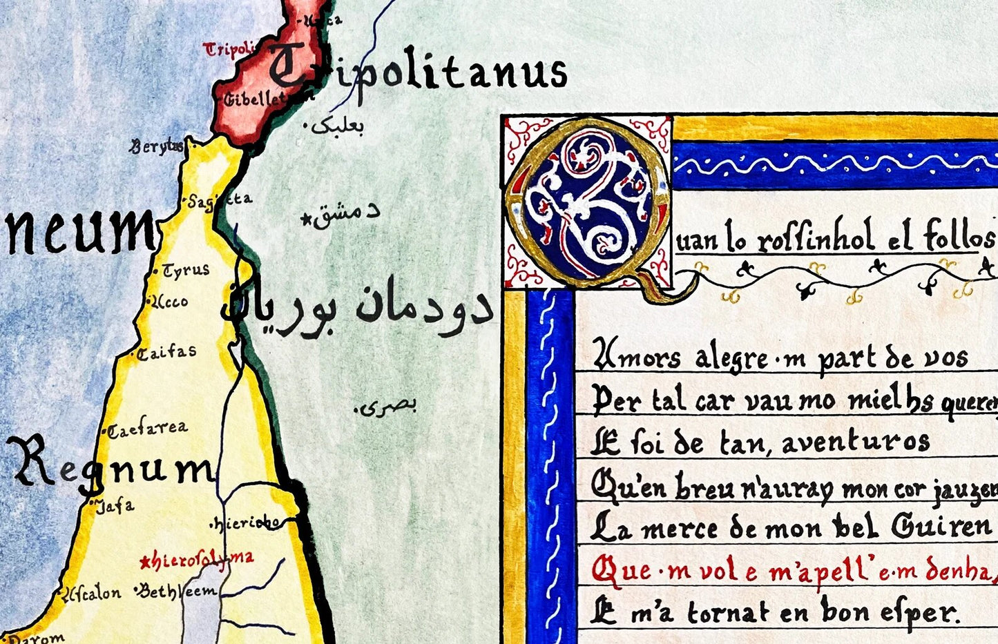
Map of the Crusader States, c. 1135 — First Crusade and the Kingdom of Jerusalem
Map of the Crusader States, c. 1135 — First Crusade and the Kingdom of Jerusalem
Couldn't load pickup availability
Hand-painted and historically researched map of the Near East in the decades following the First Crusade, circa 1135. The First Crusade (1096–1099) fundamentally reshaped the political landscape of the eastern Mediterranean, leading to the establishment of the Crusader States: the Kingdom of Jerusalem, the County of Edessa, the Principality of Antioch, and the County of Tripoli.
This map captures the fragile equilibrium that emerged in the generation after the Crusader conquest of Jerusalem. The Latin Christian polities, though territorially established, remained politically precarious—surrounded by the Fatimid Caliphate in Egypt, the Seljuk successor states, and competing regional powers. Their survival depended not only on military defense but on diplomacy, shifting alliances, and internal cohesion.
At the same time, the Byzantine Empire reasserted influence in parts of Anatolia at the expense of the Sultanate of Rûm, while Armenian Cilicia maintained a distinctive political identity amid both Greek and Latin pressures. The map emphasizes this complexity: rather than portraying a simple binary between “Crusader” and “Muslim,” it reflects the layered and contested sovereignty characteristic of the twelfth-century eastern Mediterranean.
Borders, labels, and political divisions are based on contemporary historical scholarship and reflect conditions as they would have appeared in the early twelfth century. Later territorial developments and retrospective national frameworks are intentionally excluded. The goal is to present the Crusader States not as romanticized outposts, but as historically situated polities embedded within a broader and dynamic regional system.
Stylistically, the map draws upon medieval and early cartographic aesthetics while remaining accessible to modern viewers. Scripts reflect period-appropriate linguistic conventions; for example, Greek and Latin orthography follow historical forms rather than modern standardized spellings. The included poetic excerpt—drawn from a troubadour composition concerning the Crusades (“Quan lo rossinhol el follos”)—evokes the cultural imagination of the Latin West during this period, complementing the political geography depicted.
High-quality giclée print available in multiple sizes. The printed version preserves greater clarity and detail than compressed online images.
This map was researched and hand-painted by a trained historical cartographer with academic experience in European and global history. Each CartographyCraft map is designed to prioritize historical accuracy, visual clarity, and period-appropriate aesthetics over modern anachronism. If you are interested in a print with a frame or the original, contact the site owner directly.


-
Shipping
Maps are shipped sealed in a tube via UPS, USPS, and FedEx. Please allow up to 2 weeks for your map to arrive.
-
Return Policy
Not happy with the product? Full refund on returns up to 30 days after purchase.