


CartographyCraft
The Korean War (1950–1953) — Campaign Map of the 38th Parallel and the DMZ
The Korean War (1950–1953) — Campaign Map of the 38th Parallel and the DMZ
Couldn't load pickup availability
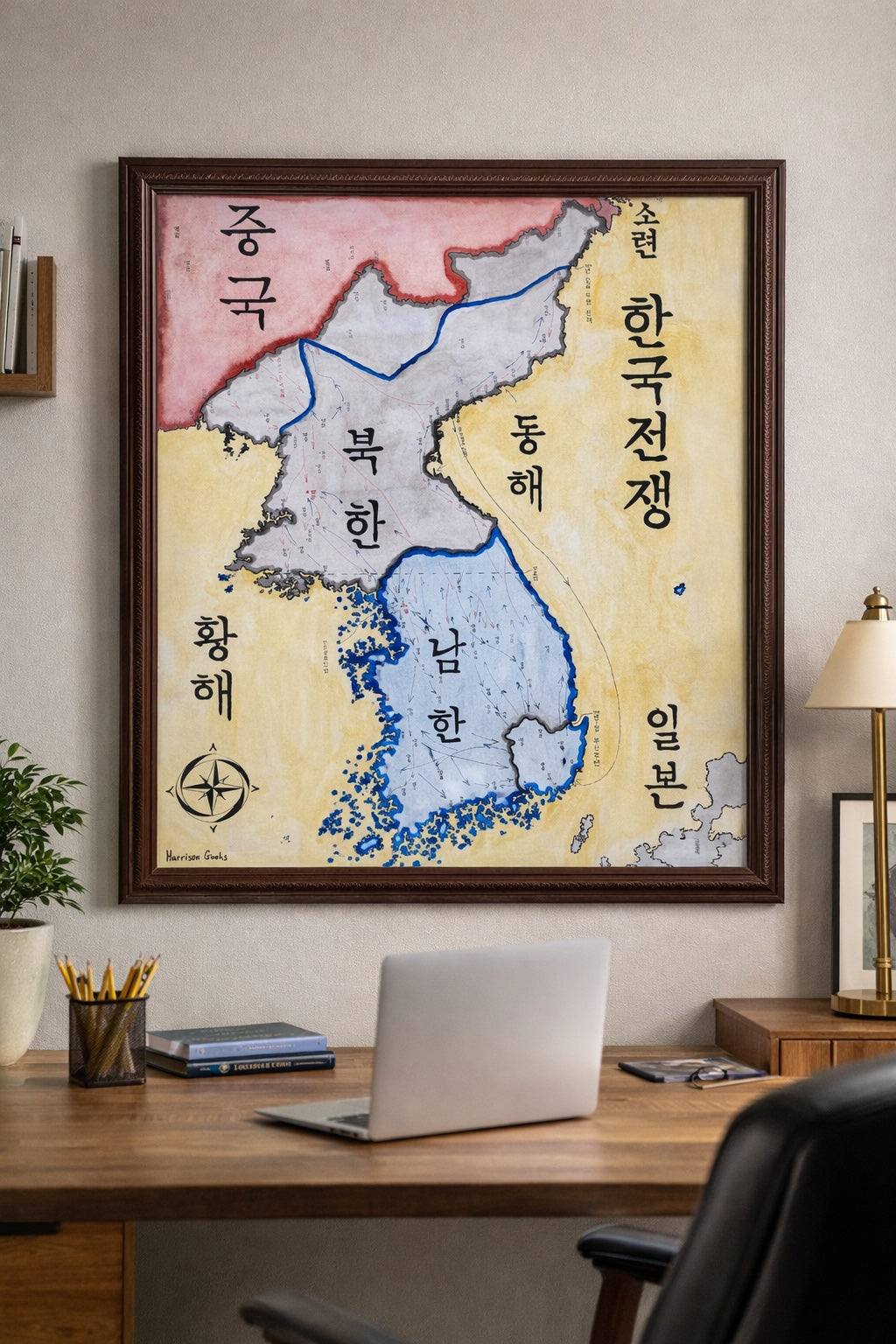
Hand-painted and historically researched map of the Korean Peninsula during the Korean War, tracing the major operational phases of the conflict from the North Korean invasion in June 1950 to the establishment of the Demilitarized Zone in 1953.
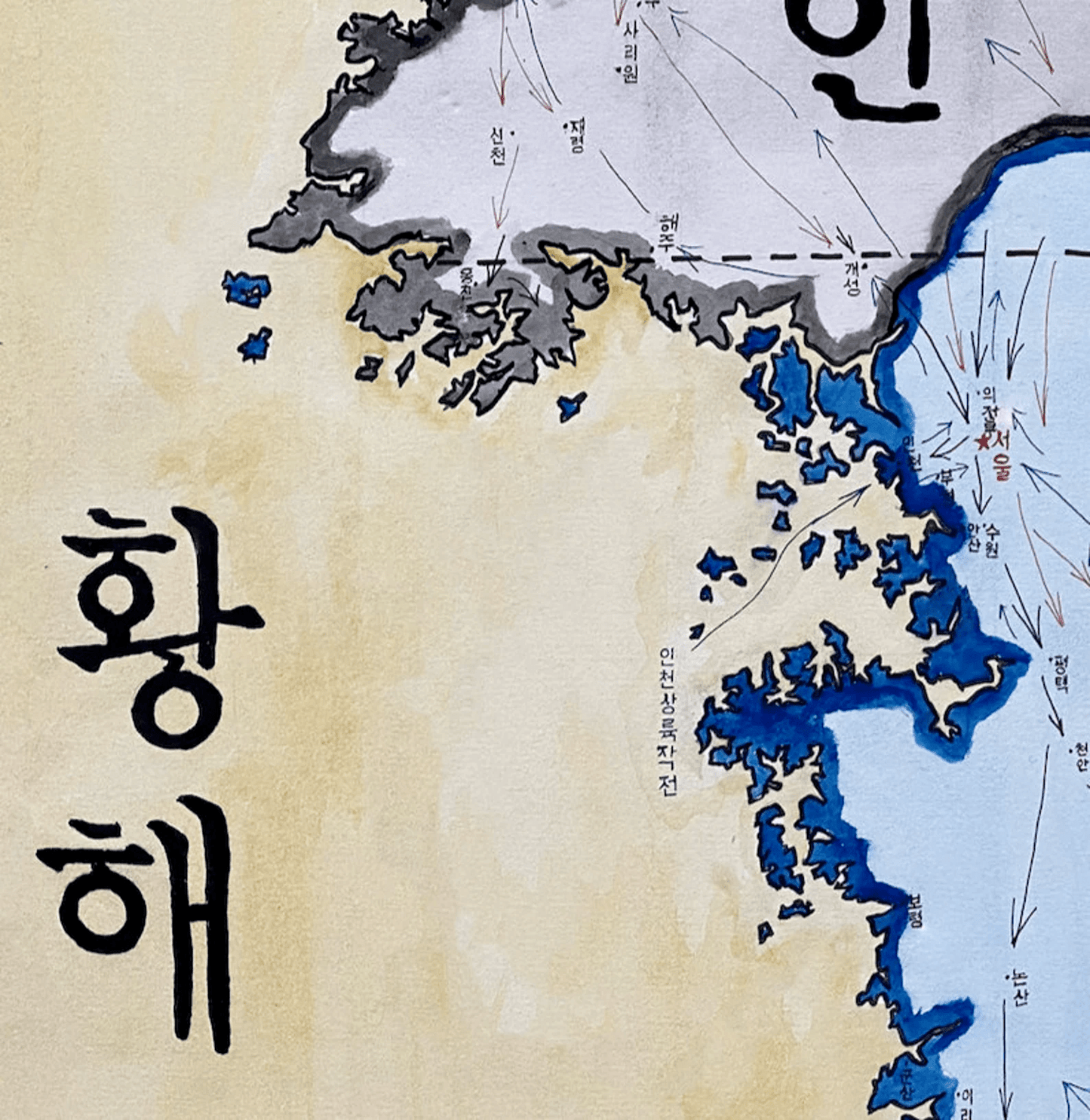
The map begins with the crossing of the 38th parallel by forces of the North Korea and the rapid southward advance that compressed United Nations and South Korean forces into the defensive perimeter around Pusan. It then follows the reversal initiated by the Inchon landing and the subsequent northward advance of UN forces toward the Yalu River. The final phase illustrates the intervention of the People's Volunteer Army, the renewed southward push, and the eventual stabilization of the front near the original dividing line.
Rather than presenting the war as a simple binary confrontation, the map emphasizes its character as an early Cold War conflict involving multiple state actors, coalition forces, and shifting front lines. The dashed line marking the eventual Demilitarized Zone reflects the armistice settlement of 1953 rather than a formal peace treaty—a distinction central to understanding the peninsula’s continuing division.
Large-scale labeling is rendered in Korean script, foregrounding the geography of the peninsula itself rather than external nomenclature. This linguistic choice situates the conflict within Korean territorial space rather than viewing it solely through superpower rivalry. Surrounding powers—including the People's Republic of China and the Soviet Union—are positioned to reflect the broader strategic context of Northeast Asia in the early 1950s.
Campaign arrows, front-line shifts, and key defensive and offensive phases are depicted to clarify the operational rhythm of the war: invasion, containment, counteroffensive, intervention, and stalemate.
Stylistically, the work balances expressive calligraphy with clear cartographic structure. Political boundaries, coastlines, and campaign movements are rendered for interpretive clarity rather than decorative effect.
Each print is produced as a high-quality giclée reproduction that preserves the detail and tonal depth of the original hand-painted map. The physical print retains greater clarity than compressed digital images.
This piece was researched and created by a trained historical cartographer with academic experience in military and Cold War history. Every CartographyCraft map prioritizes historical accuracy, geopolitical nuance, and linguistic integrity over simplified or retrospective narratives. For framed prints or inquiries regarding the original artwork, please contact the studio directly.


-
Shipping
Maps are shipped sealed in a tube via UPS, USPS, and FedEx. Please allow up to 2 weeks for your map to arrive.
-
Return Policy
Not happy with the product? Full refund on returns up to 30 days after purchase.